Challenge Information
Undergraduate and graduate students, in a team or individually, are asked to generate no more than 3 maps (one map is perfectly acceptable) that illustrate a research question related to any of the categories detailed on the second page. Particularly noteworthy submissions will have the opportunity to brief officials on their findings. These maps may be used to inform policy decisions, as well as spreading awareness about the value of geospatial analysis for health.
If you have any questions or challenges, please contact us at idmapcteam@gmail.com.
Maps can be analytic (examining relationships between multiple domains, phenomena, or data sources) or descriptive (depicting a single phenomenon or data source). While analytic projects are ideal, descriptive projects will be accepted as long as students/teams describe why their map depicts a unique phenomenon. Similarly, while international maps are preferred, domestic maps will be accepted if the student/team can provide justification as to why a map focusing on the U.S. is necessary (e.g., U.S. data sets on a given topic are the most comprehensive).
Recommended Starting Points
Data Sources
● World Health Organization
● Demographic and Health Survey
● UNICEF
● CDC National Health Interview Survey
Mapping Software
● ArcGIS (available for free trial online, as well as in many school libraries)
● Google Maps
● Adobe illustrator/InDesign (free trial available online)
To download a full PDF summary of this year's challenge, click the button below:
Next Steps
Students/teams should read about the Global Health Security Agenda, and examine maps that have been used for analyzing health and health security issues.
Examples are provided below for illustrative purposes only - students/teams are strongly encouraged to think of unique research questions that apply to the topic they are assigned.
The Global Health Security Agenda (GHSA)
Sample Maps:
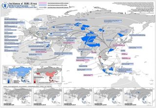
Descriptive Example:
A map depicting outbreaks of H5N1 in birds and humans
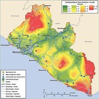
Network analysis of how central, regional, and local public health labs are connected with one another via road links